Dies ist eine alte Version des Dokuments!
Location
Das LeineLab ist im Oktober 2019 umgezogen! Ihr findet uns nicht mehr auf dem Glocksee-Gelände!
Das LeineLab residiert auf dem Gelände der ehemaligen Paul-Dohrmann-Schule. Die ehemalige Förderschule wird derzeit vom Netzwerk Transition Town betrieben, das dort in Zukunft zahlreiche Ideen umsetzen möchte.
Ihr könnt das LeineLab mit öffentlichen Verkehrsmitteln, per Fahrrad und Auto erreichen. Mit dem Rad braucht Ihr vom Hauptbahnhof etwa 15 Minuten bis zum LeineLab, mit öffentlichen Verkehrsmitteln etwa 25 Minuten (Quelle: Google Maps).
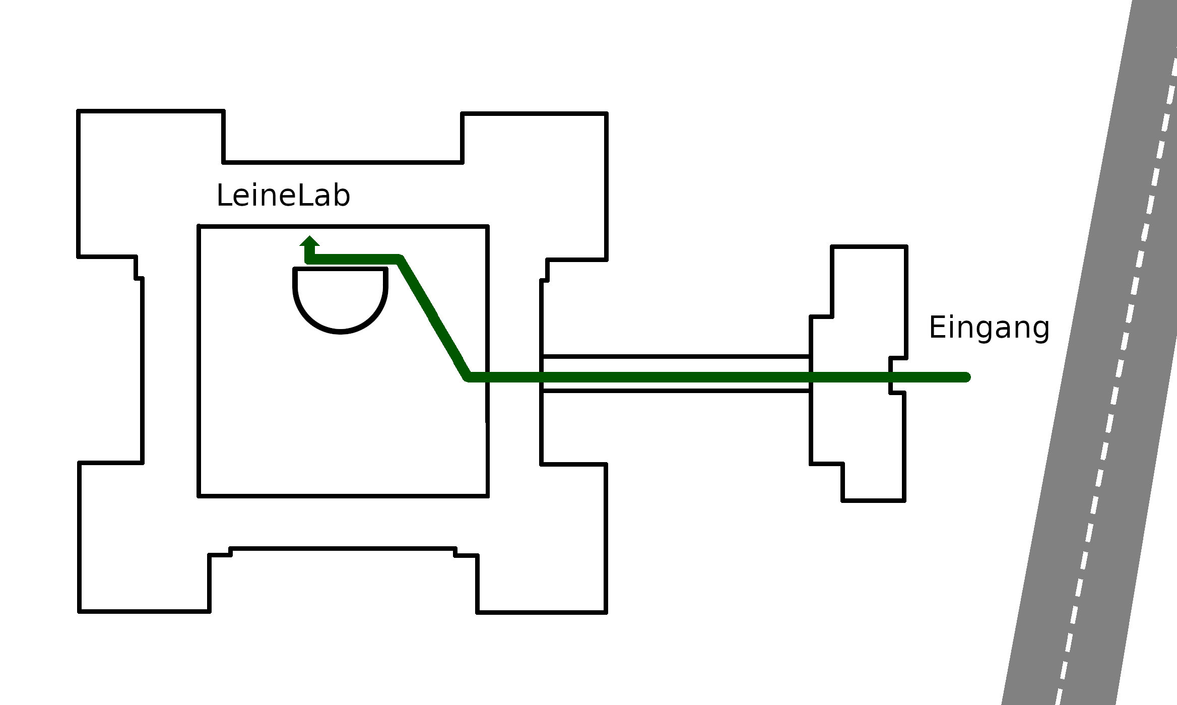
In der Schule nutzen wir einige Räume. die Ihr über den Innenhof der Schule erreichen könnt (siehe Indoor-Navigation).

| Adresse | LeineLab c/o Paul-Dohrmann-Schule/Transition Town Hannover Burgweg 5 30419 Hannover |
|||||||||||||||
|---|---|---|---|---|---|---|---|---|---|---|---|---|---|---|---|---|
| Geolocation | 52.401195, 9.703642 |
|||||||||||||||
| Navi-Link | geo:52.401195,9.703642?q=52.401195,9.703642(leinelab) |
|||||||||||||||
| OpenRouteService | https://maps.openrouteservice.org/directions?n1=52.401054&n2=9.702815&n3=17&a=null,null,52.401054,9.702815&b=0&c=0&k1=en-US&k2=km | |||||||||||||||
| Lageplan |
operating instructionsVarious functions are available as part of the map. mouse/touch operation
keyboard operationKeyboard operation becomes available after activating the map using the tab key (the map will show a focus indicator ring).
It's possible that some of the functions or buttons describe above have been disabled by the page author or the administrator
|
|||||||||||||||

Gelände der Paul-Dohrmann-Schule auf OpenStreetMap
 Eintrag in Openstreetmaps koorigieren (lassen) vgl. https://www.openstreetmap.org/way/219405811
Öffentliche Verkehrsmittel
Bahn
- bis Hannover Hauptbahnhof
- dann entweder weiter per S-Bahn oder mit Stadtbahn-Linie 6 (ab Kröpke, ca. 5 Minuten Fussweg ab HBF)
S-Bahn
Die S-Bahnen fahren ab HBF etwa alle 30 Minuten. Es gibt zwei Möglichkeiten:
- bis Hannover Bahnhof Nordstadt (Linie 1, 2, 4 oder 5) Fahrplan-Auskunft bei der Uestra
- dann Umstieg in Stadtbahn-Linie 6, Richtung Nordhafen bis Haltestelle Hainhölzer Markt
- oder bis Hannover Ledeburg (Linie 4 oder 5)
- dann zu Fuss etwa 1,5 Kilometer durch die Schrebergärten
Stadtbahn-Linie 6
- Ausstieg an der Haltestelle Hainhölzer Markt Fahrplan-Auskunft bei der Uestra
- in Richtung stadtauswärts links über die Straße ( an der Fahrrad- und Fussgängerampel)
- dem Radweg folgen (siehe Karte)
operating instructions
Various functions are available as part of the map.
mouse/touch operation
- moving by grabbing the map with a mouse-click you can move the map around
- overview map using the < button in the bottom right of the map you can expand an overview map
- zooming in and out using the + and - buttons in the top left of the map you can obtain more or less detail in the map
- switching themes or maps clicking on the ≡ icon on the right-hand side of the map you can view and select available maps and themes
- retrieving information the map may contain elements that contain more information, by clicking these a popup will show this information
- fullscreen display using the ⛶ button the map can be maximized to fullscreen display, use the ▢ button to return to page display.
keyboard operation
Keyboard operation becomes available after activating the map using the tab key (the map will show a focus indicator ring).
- moving using the arrow keys you can move the map
- overview map using the + button in the bottom right of the map you can expand an overview map
- zooming in and out using the + and - buttons in the top left of the map or by using the + and - keys you can obtain more or less detail in the map
- switching themes or maps clicking on the ≡ icon on the right-hand side of the map you can view and select available maps and themes
- retrieving information the map may contain elements that contain more information, using the i key you can activate a cursor that may be moved using the arrow keys, pressing the enter will execute an information retrieval. press the i or the escape key to return to navigation mode
- fullscreen display using the ⛶ button the map can be maximized to fullscreen display, use the ▢ button to return to page display.
It's possible that some of the functions or buttons describe above have been disabled by the page author or the administrator

| id | symbol | latitude | longitude | description |
|---|---|---|---|---|
| LeineLab Übersicht | ||||
| 1 | 52.401195º | 9.703642º | LeineLab |
|
| 2 | 52.402157º | 9.71288º | **Haltestelle Hainhölzer Markt |
|
 |
 |
GPX track: ors-export-linestring | ||
Auto
Fernverkehr
Aus Richtung Minden
- Autobahn A2 bis Ausfahrt Herrenhausen
- auf der B6 Richtung Herrenhausen, Innenstadt
- nach etwa 2 Kilometer rechts auf Herrenhäuser Straße abbiegen
- nach einem Kilometer links auf Burgweg einbiegen
operating instructions
Various functions are available as part of the map.
mouse/touch operation
- moving by grabbing the map with a mouse-click you can move the map around
- overview map using the < button in the bottom right of the map you can expand an overview map
- zooming in and out using the + and - buttons in the top left of the map you can obtain more or less detail in the map
- switching themes or maps clicking on the ≡ icon on the right-hand side of the map you can view and select available maps and themes
- retrieving information the map may contain elements that contain more information, by clicking these a popup will show this information
- fullscreen display using the ⛶ button the map can be maximized to fullscreen display, use the ▢ button to return to page display.
keyboard operation
Keyboard operation becomes available after activating the map using the tab key (the map will show a focus indicator ring).
- moving using the arrow keys you can move the map
- overview map using the + button in the bottom right of the map you can expand an overview map
- zooming in and out using the + and - buttons in the top left of the map or by using the + and - keys you can obtain more or less detail in the map
- switching themes or maps clicking on the ≡ icon on the right-hand side of the map you can view and select available maps and themes
- retrieving information the map may contain elements that contain more information, using the i key you can activate a cursor that may be moved using the arrow keys, pressing the enter will execute an information retrieval. press the i or the escape key to return to navigation mode
- fullscreen display using the ⛶ button the map can be maximized to fullscreen display, use the ▢ button to return to page display.
It's possible that some of the functions or buttons describe above have been disabled by the page author or the administrator

| id | symbol | latitude | longitude | description |
|---|---|---|---|---|
| LeineLab Anfahrt aus Richtung Westen | ||||
| 1 | 52.401195º | 9.703642º | LeineLab, Burgweg 5, 30419 Hannover |
|
|
|
GPX track: auto-west-leinelab | ||
Aus Richtung Norden (Hamburg) und Osten (Berlin)
Auf der A7 Richtung Hannover am Dreieck Hannover Nord, Richtung Hannover, abfahren (A352) An der Abfahrt Hannover Flughafen Richtung Hannover Innenstadt abfahren (B522, Flughafenschnellweg) Auf der Vahrenwalder Straße etwa 3 Kilometer weiter, dann rechts auf Melanchthonstraße abbiegen An der Kreuzung Melanchthonstraße/Schulenburger Landstraße auf die Schulenburger Landstraße rechts abbiegen
operating instructions
Various functions are available as part of the map.
mouse/touch operation
- moving by grabbing the map with a mouse-click you can move the map around
- overview map using the < button in the bottom right of the map you can expand an overview map
- zooming in and out using the + and - buttons in the top left of the map you can obtain more or less detail in the map
- switching themes or maps clicking on the ≡ icon on the right-hand side of the map you can view and select available maps and themes
- retrieving information the map may contain elements that contain more information, by clicking these a popup will show this information
- fullscreen display using the ⛶ button the map can be maximized to fullscreen display, use the ▢ button to return to page display.
keyboard operation
Keyboard operation becomes available after activating the map using the tab key (the map will show a focus indicator ring).
- moving using the arrow keys you can move the map
- overview map using the + button in the bottom right of the map you can expand an overview map
- zooming in and out using the + and - buttons in the top left of the map or by using the + and - keys you can obtain more or less detail in the map
- switching themes or maps clicking on the ≡ icon on the right-hand side of the map you can view and select available maps and themes
- retrieving information the map may contain elements that contain more information, using the i key you can activate a cursor that may be moved using the arrow keys, pressing the enter will execute an information retrieval. press the i or the escape key to return to navigation mode
- fullscreen display using the ⛶ button the map can be maximized to fullscreen display, use the ▢ button to return to page display.
It's possible that some of the functions or buttons describe above have been disabled by the page author or the administrator
| id | symbol | latitude | longitude | description |
|---|---|---|---|---|
| LeineLab Anfahrt aus Richtung Norden | ||||
| 1 | 52.401195º | 9.703642º | LeineLab, Burgweg 5, 30419 Hannover |
|
|
|
GPX track: auto-nord-leinelab | ||
Aus Richtung Süden, Hildesheim
operating instructions
Various functions are available as part of the map.
mouse/touch operation
- moving by grabbing the map with a mouse-click you can move the map around
- overview map using the < button in the bottom right of the map you can expand an overview map
- zooming in and out using the + and - buttons in the top left of the map you can obtain more or less detail in the map
- switching themes or maps clicking on the ≡ icon on the right-hand side of the map you can view and select available maps and themes
- retrieving information the map may contain elements that contain more information, by clicking these a popup will show this information
- fullscreen display using the ⛶ button the map can be maximized to fullscreen display, use the ▢ button to return to page display.
keyboard operation
Keyboard operation becomes available after activating the map using the tab key (the map will show a focus indicator ring).
- moving using the arrow keys you can move the map
- overview map using the + button in the bottom right of the map you can expand an overview map
- zooming in and out using the + and - buttons in the top left of the map or by using the + and - keys you can obtain more or less detail in the map
- switching themes or maps clicking on the ≡ icon on the right-hand side of the map you can view and select available maps and themes
- retrieving information the map may contain elements that contain more information, using the i key you can activate a cursor that may be moved using the arrow keys, pressing the enter will execute an information retrieval. press the i or the escape key to return to navigation mode
- fullscreen display using the ⛶ button the map can be maximized to fullscreen display, use the ▢ button to return to page display.
It's possible that some of the functions or buttons describe above have been disabled by the page author or the administrator
| id | symbol | latitude | longitude | description |
|---|---|---|---|---|
| LeineLab Anfahrt aus Richtung Süden | ||||
| 1 | 52.401195º | 9.703642º | LeineLab, Burgweg 5, 30419 Hannover |
|
|
|
GPX track: auto-sued-leinelab | ||